
Google Maps is introducing a new feature that enhances user location accuracy when navigating through tunnels by utilizing Bluetooth sensors known as BLE technology transmitters. These transmitters send identifiers to nearby mobile devices, enabling them to perform actions when in close proximity.
Google Maps now has a new functionality that utilizes Bluetooth sensors.
When Google Maps shows a tunnel in the route, issues often arise because cell phone GPS signals cannot reach underground. However, a solution to this problem is the use of “bluetooth sensors”.
Bluetooth sensors placed strategically can enhance GPS accuracy in tunnels by scanning the positioning effectively.
This technology is utilized in certain shopping centers worldwide. The Waze app includes the Bluetooth sensor feature in various cities such as New York, Chicago, Paris, Rio, Brussels, Oslo, Sydney, Boston, and Mexico City.
Introduction and release dates
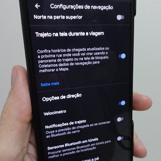
The precision enhancement feature in Google Maps tunnels is now available to all users but is turned off by default. To enable it, navigate to “Settings” > “Setting Settings” > Bluetooth sensors in tunnels. Note that Bluetooth sensors in your city’s tunnels are required for this feature to work.